TagRanger®
How to perform Live Tracking
Live Tracking works by having your Tag transmit its location on a schedule that you define.
This can work in three ways; A user can receive the transmissions on their Finder while out in the field, a Finder left in a strategic location can gather and store these transmissions in to a log file or you can receive these messages on your own private LoRaWAN network to build a log file on your network.
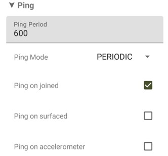
Live tracking is simply enabled by setting the 'Ping Mode' in your Tag configuration to "GNSSUPDATE" and setting the 'GPS Period' to the time between each position attempt.

Ping Period - This is ignored if GNSSUPDATE mode is selected
Ping Mode - Must be set to GNSSUPDATE to ping whenever a GPS position is acquired
Ping on joined - Recommend to keep this setting on
Ping on surfaced - Reserved for marine deployments
Ping on Accelerometer - Send a ping including the last GPS location when the accelerometer is activated (activation settings configured separately)

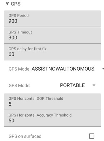
GPS Period - Set the time (in seconds) before the next GPS attempt
GPS Timeout - How long the GPS should attempt to get a fix (location) before aborting
GPS delay for first fix - The delay after your Tag is deployed before the first attempt to get a GPS fix
GPS Mode - Sets which assist mode to use (if any):
-
- UNASSISTED - Longest time to get a fix
- ASSISTNOWAUTONOMOUS - After the first fix the GNSS will build a database of local satellites to speed up acquisition time. This database will go stale if there is a long gap between fixes
- ASSISTNOWOFFLINE - It is possible to upload an Almanac before deployment which will speed up the GNSS fix time for up to 6 weeks
- ASSISTNOWHYBRID - This mode starts off using an Almanac, then as the Almanac goes stale it reverts to ASSISTNOWAUTONOMOUS
GPS Model - This presets a number of GNSS parameters to optimise the performance. It should not normally be necessary to change this setting
GPS horizontal DOP Threshold - Sets the acceptable accuracy of the GNSS before declaring a fix (may be increased by a few points to speed up fix time at the expense of accuracy)
GPS Horizontal Accuracy Threshold - Sets the acceptable accuracy of the GNSS before declaring a fix (may be increased by 50/100/150 to speed up fix time at the expense of accuracy)
Notes:
- Using the TagRanger® App you can view the last received location on the map and download the GPS log from the Finder
- If you are using your own private LoRaWAN network you can store the messages on your own server
